NEWS
Major Hurricane Milton Threatens Southwest Florida with Life-Threatening Storm Surge
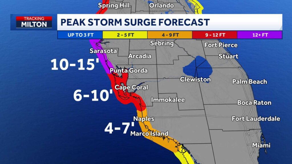
FORT MYERS, Fla. — Hurricane Milton rapidly intensified into a Category 5 storm in the southwestern Gulf, with winds exceeding 180 mph. The National Hurricane Center (NHC) issued a storm surge warning for coastal areas of Southwest Florida, including 5-10 feet of surge expected in Lee and Charlotte counties. Collier County could see 4-7 feet. A hurricane warning is in place for parts of the west coast of Florida, covering Charlotte, DeSoto, and Lee counties, while a hurricane watch remains for Collier, Glades, and Hendry counties.

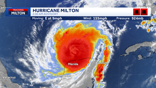
As of the 2 a.m. update from the NHC, Hurricane Milton’s sustained winds reached 155 mph. The storm slightly weakened due to an eyewall replacement cycle, downgrading it to Category 4. The central pressure sits at 924 mb, and the storm is moving eastward at 9 mph. Milton is located approximately 585 miles southwest of Tampa.
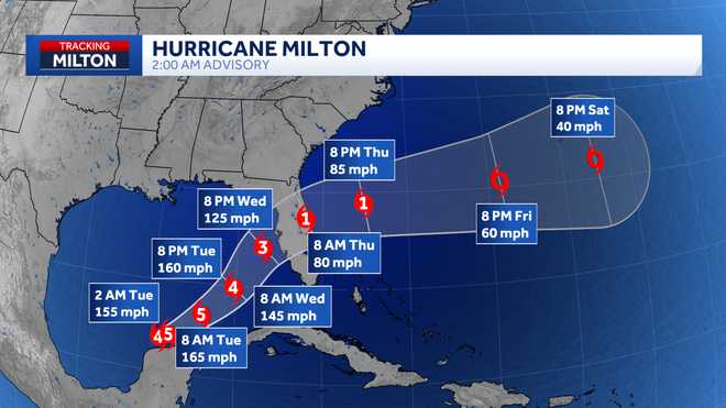

Milton is projected to move toward the western coast of Florida over the next few days, likely making landfall on Wednesday evening as a major hurricane. Although it is forecast to weaken to a Category 3 due to wind shear, significant life-threatening impacts are still expected. The forecast cone from the NHC shows where the storm’s center is most likely to track. Focusing solely on the cone’s center could mislead individuals into underestimating the storm’s impact. Those within the cone’s southern range could experience stronger winds and greater storm surge.
![]()

For coastal regions under mandatory evacuation orders, officials urge residents to evacuate immediately due to the threat of rising water levels. Storm surge could reach 5-10 feet in Charlotte and Lee counties, including areas along the Peace River and Caloosahatchee River. Collier County’s coastal areas, such as Vanderbilt Beach, also face dangerous flooding risks. Water levels may rise high enough to submerge structures in these regions. Residents should not underestimate the danger posed by wind and rain either. Gusts exceeding 75 mph are expected along Southwest Florida’s coast, with tropical storm-strength winds impacting portions of Hendry and eastern Collier counties.
South Florida is already experiencing a tropical air mass, boosting rainfall chances ahead of Hurricane Milton’s landfall. The NHC has issued a Flood Watch for the entire region through Thursday morning. Excessive rainfall of 4 to 8 inches or more is expected, which could lead to the flooding of rivers, creeks, streams, and other flood-prone areas.
![]()
Milton’s rapid movement through the Gulf means that there won’t be a long waiting period for storm impacts. Tropical-storm-force winds are expected to arrive in Florida by 8 a.m. on Wednesday. Residents should complete outdoor preparations by Tuesday evening.
Residents in Southwest Florida are urged to stay updated through local news outlets and the NHC. Evacuation orders, storm surge updates, and other vital information will continue to be issued as the storm approaches.